
- The first dataset I downloaded from ASN for playing around with was the Tumba Lidar.
- I had thought it might be better to offer this as a OGC service rather than downloadable geotiff
- just in terms of the size firstly (104MB)
- but I also soon realised it would need some specialised tweaking which non-GIS users might struggle a bit and could avoid if the serverside data is set up by a GIS specialist (although can we assume only GIS specialists will download this kind of data)?
- kudos to http://stackoverflow.com/questions/11966503/how-to-replace-nas-in-a-raster-object
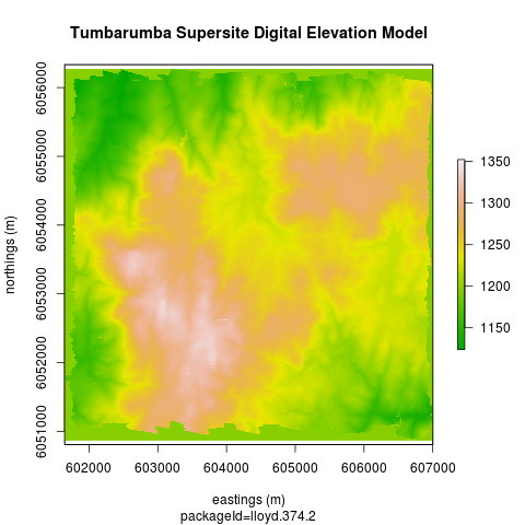
Code:tumbarumba-supersite-dem
setwd("~/data/supersite/tumba-lidar")
require(raster)
fname  <- dir(pattern = "tif$")
fname
r  <- raster(fname)
str(r)
dfr <- as.data.frame(r)
summary(dfr)
# the -1 code looks like it might be missing?  They are around the edge.
rna <- reclassify(r, cbind(-1, 1197))
png("tumba-lidar.png")
plot(rna, col=terrain.colors(100), xlab = "eastings (m)", ylab = "northings (m)")
title("Tumbarumba Supersite Digital Elevation Model")
title(sub = "packageId=lloyd.374.2")
dev.off()
Alternately use a geoserver
- If we use a Geoserver we could set it up so people can view this without downloading the data
- following the instructions http://suite.opengeo.org/opengeo-docs/processing/contour/setup.html
- using the ANU GIS library server
;
- PS the map might take a minute to show up, not sure why, might ask the sysadmin to look at the server performance


